
Thank you for supporting this site ❤️
Make a donation
Make a donation
Beverly Hills topographic map
Click on the map to display elevation.
Thank you for supporting this site ❤️
Make a donation
Make a donation
About this map
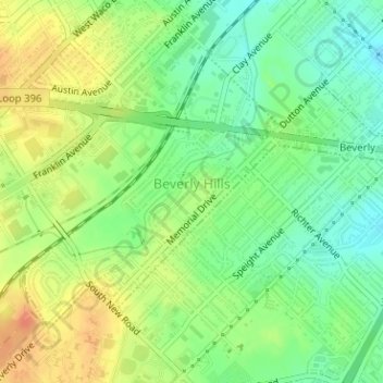
Name: Beverly Hills topographic map, elevation, terrain.
Location: Beverly Hills, McLennan County, Texas, United States (31.51241 -97.16943 31.53154 -97.13819)
Average elevation: 160 m
Minimum elevation: 140 m
Maximum elevation: 182 m
Thank you for supporting this site ❤️
Make a donation
Make a donation
Other topographic maps
Click on a map to view its topography, its elevation and its terrain.
Thank you for supporting this site ❤️
Make a donation
Make a donation
Northcrest
United States > Texas > McLennan County > Lacy-Lakeview > Northcrest
Average elevation: 149 m
Thank you for supporting this site ❤️
Make a donation
Make a donation