
Thank you for supporting this site ❤️
Make a donation
Make a donation
Hammelspring topographic map
Click on the map to display elevation.
Thank you for supporting this site ❤️
Make a donation
Make a donation
About this map
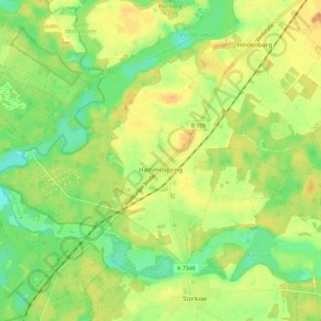
Name: Hammelspring topographic map, elevation, terrain.
Location: Hammelspring, Templin, Uckermark, Brandenburg, Deutschland (53.05181 13.37830 53.09347 13.47601)
Average elevation: 55 m
Minimum elevation: 37 m
Maximum elevation: 70 m
Thank you for supporting this site ❤️
Make a donation
Make a donation
Other topographic maps
Click on a map to view its topography, its elevation and its terrain.