
Thank you for supporting this site ❤️
Make a donation
Make a donation
Veitriedhausen topographic map
Click on the map to display elevation.
Thank you for supporting this site ❤️
Make a donation
Make a donation
About this map
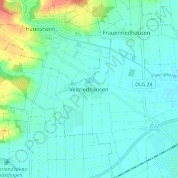
Name: Veitriedhausen topographic map, elevation, terrain.
Average elevation: 446 m
Minimum elevation: 434 m
Maximum elevation: 491 m
Thank you for supporting this site ❤️
Make a donation
Make a donation
Other topographic maps
Click on a map to view its topography, its elevation and its terrain.
89415
Deutschland > Bayern > Landkreis Dillingen an der Donau > Lauingen (Donau)
Average elevation: 431 m