
Thank you for supporting this site ❤️
Make a donation
Make a donation
Chimborazo topographic map
Click on the map to display elevation.
Thank you for supporting this site ❤️
Make a donation
Make a donation
About this map
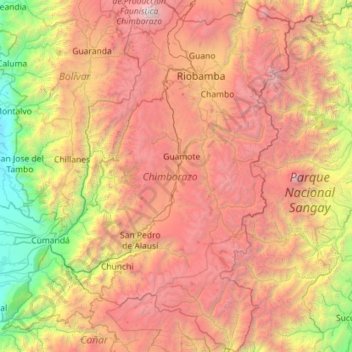
Name: Chimborazo topographic map, elevation, terrain.
Location: Chimborazo, Ecuador (-2.56733 -79.25441 -1.43013 -78.35854)
Average elevation: 2,664 m
Minimum elevation: 15 m
Maximum elevation: 6,224 m
Thank you for supporting this site ❤️
Make a donation
Make a donation
Other topographic maps
Click on a map to view its topography, its elevation and its terrain.
Isla Plaza Sur
Ecuador > Galápagos > Cantón Santa Cruz
South Plaza (Spanish: Isla Plaza Sur) is a small island off the east coast of Santa Cruz in the Galápagos Islands. It has an area of 0.13 km2 and a maximum altitude of 23 metres.
Average elevation: 5 m