
Thank you for supporting this site ❤️
Make a donation
Make a donation
Le Cadet topographic map
Click on the map to display elevation.
Thank you for supporting this site ❤️
Make a donation
Make a donation
About this map
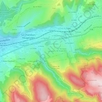
Name: Le Cadet topographic map, elevation, terrain.
Average elevation: 621 m
Minimum elevation: 478 m
Maximum elevation: 863 m
Thank you for supporting this site ❤️
Make a donation
Make a donation
Other topographic maps
Click on a map to view its topography, its elevation and its terrain.
Parc du Bouchet
France > Auvergne-Rhône-Alpes > Loire > Le Chambon-Feugerolles
Average elevation: 566 m