
Make a donation
Barahona topographic map
Click on the map to display elevation.
Make a donation
About this map
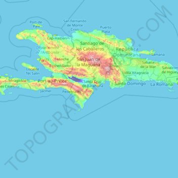
Name: Barahona topographic map, elevation, terrain.
Location: Barahona, Dominican Republic (15.57148 -73.80953 20.77148 -68.60953)
Average elevation: 88 m
Minimum elevation: -44 m
Maximum elevation: 2,981 m
Make a donation
Other topographic maps
Click on a map to view its topography, its elevation and its terrain.
Monte Cristi
The Montecristi province limits to the North with the Atlantic Ocean: to the South with the provinces Dajabón and Santiago Rodríguez; to the East with the Valverde province and to the West with the Atlantic Ocean and the Republic of Haiti. The Montecristi province is fundamentally an immense plain with many…
Average elevation: 94 m
San Francisco de Macorís
The relief of Duarte Province ranges from 17 to 942 metres (56 to 3,091 ft) above sea level, reaching its highest elevation at "Loma Quita Espuela". This name allegedly comes from the time when the Spaniards were exploring the island, since the hill was too steep to ride their horses, they had to dismount and…
Average elevation: 218 m
Make a donation
Santiago
Santiago de los Caballeros ("Saint James of the Knights"), often shortened to Santiago, is the second-largest city in the Dominican Republic and the fourth-largest city in the Caribbean by population. It is the capital of Santiago Province and the largest major metropolis in the Cibao region of the country.…
Average elevation: 716 m
Make a donation
Constanza
The town of Constanza is located at a height of 1220 meters (4000 ft) above sea level in the middle of the Cordillera Central (Central Range), the tallest mountain range in the island of Hispaniola and the entire Caribbean region. The annual average temperatures range from 41 °F (5 °C) to 68 °F (20 °C),…
Average elevation: 1,473 m
Make a donation
Santiago de los Caballeros
Santiago de los Caballeros ("Saint James of the Knights"), often shortened to Santiago, is the second-largest city in the Dominican Republic and the fourth-largest city in the Caribbean by population. It is the capital of Santiago Province and the largest major metropolis in the Cibao region of the country.…
Average elevation: 341 m
Make a donation
Jarabacoa
Jarabacoa has a Tropical rainforest climate (Köppen climate classification Af ). Due to its high elevation in the interior it has warm days and lower temperatures at nights during most of the year, and temperate days and colder nights during winter months. Because of its climate, visitors have christened…
Average elevation: 947 m
Make a donation
Make a donation
Monte Cristi
The Montecristi province limits to the North with the Atlantic Ocean: to the South with the provinces Dajabón and Santiago Rodríguez; to the East with the Valverde province and to the West with the Atlantic Ocean and the Republic of Haiti. The Montecristi province is fundamentally an immense plain with many…
Average elevation: 94 m
Make a donation
Santiago
Santiago de los Caballeros (English: Saint James of the Knights), often shortened to Santiago, is the second-largest city in the Dominican Republic and the fourth-largest city in the Caribbean by population. It is the capital of Santiago Province and the largest major metropolis in the Cibao region of the…
Average elevation: 716 m
Make a donation
Make a donation
Santiago de los Caballeros
Santiago de los Caballeros ("Saint James of the Knights"), often shortened to Santiago, is the second-largest city in the Dominican Republic and the fourth-largest city in the Caribbean by population. It is the capital of Santiago Province and the largest major metropolis in the Cibao region of the country.…
Average elevation: 341 m
Make a donation
Jarabacoa
Jarabacoa has a Tropical rainforest climate (Köppen climate classification Af ). Due to its high elevation in the interior it has warm days and lower temperatures at nights during most of the year, and temperate days and colder nights during winter months. Because of its climate, visitors have christened…
Average elevation: 947 m
Make a donation
Monte Cristi
The Montecristi province limits to the North with the Atlantic Ocean: to the South with the provinces Dajabón and Santiago Rodríguez; to the East with the Valverde province and to the West with the Atlantic Ocean and the Republic of Haiti. The Montecristi province is fundamentally an immense plain with many…
Average elevation: 94 m
Make a donation
Make a donation
Catalina Island
Dominican Republic > La Romana > La Romana > Caleta
The island itself is only 9.6 square kilometers in size, and is a diverse preservation of eco-systems including sand dunes, mangroves, and reefs. Formed out of coral stone, the island contains three overlapping plateaus. The highest elevation on the island is only 60 feet above sea level. The seas around the…
Average elevation: 2 m
Make a donation
Jarabacoa
Jarabacoa has a Tropical rainforest climate (Köppen climate classification Af ). Due to its high elevation in the interior it has warm days and lower temperatures at nights during most of the year, and temperate days and colder nights during winter months. Because of its climate, visitors have christened…
Average elevation: 947 m
Catalina Island
Dominican Republic > La Romana > La Romana > Caleta
The island itself is only 9.6 square kilometers in size, and is a diverse preservation of eco-systems including sand dunes, mangroves, and reefs. Formed out of coral stone, the island contains three overlapping plateaus. The highest elevation on the island is only 60 feet above sea level. The seas around the…
Average elevation: 2 m
Make a donation
Make a donation
Make a donation
Make a donation