
Make a donation
Segura de Toro topographic map
Click on the map to display elevation.
Make a donation
Segura de Toro
Segura de Toro is a Spanish village in the north of the province of Cáceres. There are some Celtic remains which can indicate a possible Celtic origin. It is situated by the Tras la Sierra mountains at an altitude of 715 m. It has several streams, and the main one being Garganta Ancha. The village has a Mediterranean climate and its pluviosity is 986.4 m/m. It's built on a granite formation and there are chestnuts and oaks surrounded by tree heaths and genista.
Make a donation
About this map
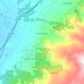
Name: Segura de Toro topographic map, elevation, terrain.
Location: Segura de Toro, Cáceres, Extremadura, Spain (40.19823 -5.97921 40.23443 -5.88869)
Average elevation: 784 m
Minimum elevation: 387 m
Maximum elevation: 1,796 m
Make a donation
Other topographic maps
Click on a map to view its topography, its elevation and its terrain.
Make a donation
Castillo de Piedrabuena
Spain > Extremadura > Tierra de Badajoz > San Vicente de Alcántara > Dehesa Piedrabuena
Average elevation: 364 m
Make a donation
Make a donation
Make a donation