
Thank you for supporting this site ❤️
Make a donation
Make a donation
Wilden topographic map
Click on the map to display elevation.
Thank you for supporting this site ❤️
Make a donation
Make a donation
Wilden
Der Ort hat eine Gemarkungsfläche von 7,21 km² und liegt, bedingt durch seine Länge auf einer Höhe zwischen 300 m über NN beim Ortsausgang in Richtung Salchendorf und 370 m über NN beim Ortsausgang Oberwilden in Richtung Wilnsdorf.
Thank you for supporting this site ❤️
Make a donation
Make a donation
About this map
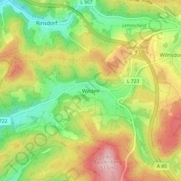
Name: Wilden topographic map, elevation, terrain.
Average elevation: 384 m
Minimum elevation: 280 m
Maximum elevation: 512 m
Thank you for supporting this site ❤️
Make a donation
Make a donation