
Thank you for supporting this site ❤️
Make a donation
Make a donation
Ga-Mamatlhola topographic map
Click on the map to display elevation.
Thank you for supporting this site ❤️
Make a donation
Make a donation
About this map
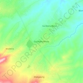
Name: Ga-Mamatlhola topographic map, elevation, terrain.
Average elevation: 596 m
Minimum elevation: 523 m
Maximum elevation: 757 m
Thank you for supporting this site ❤️
Make a donation
Make a donation
Other topographic maps
Click on a map to view its topography, its elevation and its terrain.
Kapama Game Reserve
South Africa > Limpopo > Mopani District Municipality > Maruleng Local Municipality
Average elevation: 536 m
Selati Nature Reserve
South Africa > Limpopo > Mopani District Municipality > Maruleng Local Municipality
Average elevation: 585 m