
Thank you for supporting this site ❤️
Make a donation
Make a donation
Esslinger Tor topographic map
Click on the map to display elevation.
Thank you for supporting this site ❤️
Make a donation
Make a donation
About this map
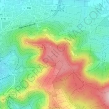
Name: Esslinger Tor topographic map, elevation, terrain.
Average elevation: 368 m
Minimum elevation: 284 m
Maximum elevation: 497 m
Thank you for supporting this site ❤️
Make a donation
Make a donation
Other topographic maps
Click on a map to view its topography, its elevation and its terrain.
Fellbach
Deutschland > Baden-Württemberg > Rems-Murr-Kreis > Fellbach
Die Bundesstraße 14 (Schwäbisch Hall–Stuttgart) führte durch die Stadt, bis 1992 der 1600 Meter langen Kappelbergtunnel eröffnet wurde, der den Durchgangsverkehr um das südliche Stadtgebiet herumleitet. Da ein Nordostring Stuttgart auch aufgrund von Widerstand aus Fellbach bisher nicht gebaut wurde,…
Average elevation: 315 m
Thank you for supporting this site ❤️
Make a donation
Make a donation