
Thank you for supporting this site ❤️
Make a donation
Make a donation
Mount Robertson topographic map
Click on the map to display elevation.
Thank you for supporting this site ❤️
Make a donation
Make a donation
About this map
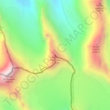
Name: Mount Robertson topographic map, elevation, terrain.
Average elevation: 2,769 m
Minimum elevation: 2,305 m
Maximum elevation: 3,387 m
Thank you for supporting this site ❤️
Make a donation
Make a donation
Other topographic maps
Click on a map to view its topography, its elevation and its terrain.
Peter Lougheed Provincial Park
Canada > Alberta > Kananaskis Improvement District
Average elevation: 2,181 m
Bow Valley Provincial Park
Canada > Alberta > Kananaskis Improvement District
Average elevation: 1,705 m
West Bragg Creek Provincial Recreation Area
Canada > Alberta > Kananaskis Improvement District
Average elevation: 1,467 m
Thank you for supporting this site ❤️
Make a donation
Make a donation
Thank you for supporting this site ❤️
Make a donation
Make a donation