
Thank you for supporting this site ❤️
Make a donation
Make a donation
Sukolilo topographic map
Click on the map to display elevation.
Thank you for supporting this site ❤️
Make a donation
Make a donation
About this map
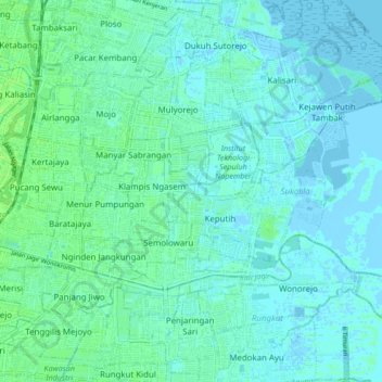
Name: Sukolilo topographic map, elevation, terrain.
Location: Sukolilo, Surabaya, East Java, Java, Indonesia (-7.31080 112.76188 -7.26743 112.84668)
Average elevation: 3 m
Minimum elevation: -4 m
Maximum elevation: 9 m
Thank you for supporting this site ❤️
Make a donation
Make a donation
Other topographic maps
Click on a map to view its topography, its elevation and its terrain.
Thank you for supporting this site ❤️
Make a donation
Make a donation
Thank you for supporting this site ❤️
Make a donation
Make a donation