
Thank you for supporting this site ❤️
Make a donation
Make a donation
Escalos de Cima e Lousa topographic map
Click on the map to display elevation.
Thank you for supporting this site ❤️
Make a donation
Make a donation
About this map
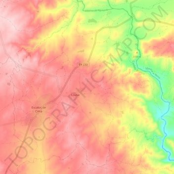
Name: Escalos de Cima e Lousa topographic map, elevation, terrain.
Location: Escalos de Cima e Lousa, Castelo Branco, Portugal (39.89819 -7.42384 39.98281 -7.32133)
Average elevation: 331 m
Minimum elevation: 177 m
Maximum elevation: 417 m
Thank you for supporting this site ❤️
Make a donation
Make a donation
Other topographic maps
Click on a map to view its topography, its elevation and its terrain.