
Make a donation
Monument Park topographic map
Click on the map to display elevation.
Make a donation
About this map
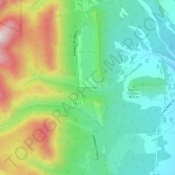
Name: Monument Park topographic map, elevation, terrain.
Location: Monument Park, Las Animas County, Colorado, United States (37.18583 -105.06654 37.22583 -105.02654)
Average elevation: 2,672 m
Minimum elevation: 2,462 m
Maximum elevation: 3,084 m
Make a donation
Other topographic maps
Click on a map to view its topography, its elevation and its terrain.
Trinidad Lake State Park
United States > Colorado > Las Animas County > Trinidad
Average elevation: 1,966 m
Kim
United States > Colorado > Las Animas County
Kim is located on the plains of southeastern Colorado and the elevation is 5690 ft (1734 m).
Average elevation: 1,735 m
Make a donation
Kim
United States > Colorado > Las Animas County
Kim is located on the plains of southeastern Colorado and the elevation is 5690 ft (1734 m).
Average elevation: 1,734 m