
Thank you for supporting this site ❤️
Make a donation
Make a donation
Cavite City topographic map
Click on the map to display elevation.
Thank you for supporting this site ❤️
Make a donation
Make a donation
About this map
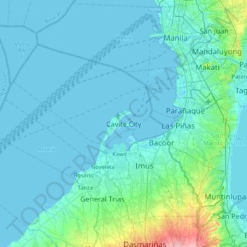
Name: Cavite City topographic map, elevation, terrain.
Location: Cavite City, Cavite, Calabarzon, 4100, Philippines (14.32203 120.74891 14.64203 121.06891)
Average elevation: 13 m
Minimum elevation: -3 m
Maximum elevation: 129 m
Thank you for supporting this site ❤️
Make a donation
Make a donation
Other topographic maps
Click on a map to view its topography, its elevation and its terrain.
Caballo Island
Philippines > Cavite > Cavite City
Caballo Island (which means "Horse Island" in Spanish) is a bluff, rocky island located at the entrance to Manila Bay in the Philippines. It is about 1.2 km (0.75 mi) long with the highest elevation at 381 feet high. Caballo, along with the larger Corregidor (2 km to the north), divides the entrance to the bay…
Average elevation: 0 m