
Ussel topographic map
Click on the map to display elevation.
Ussel
The community of Ussel is located in the Massif central on the foothills of the plateau de Millevaches. The city itself sits on a hilltop in between the valley of the river Diège and the valley of the river Sarsonne. It is situated at an altitude of 2070 ft (631 m), in the Massif Central on the last buttress of the Plateau de Millevaches. Ussel is crossed by the Green Meridian.
About this map
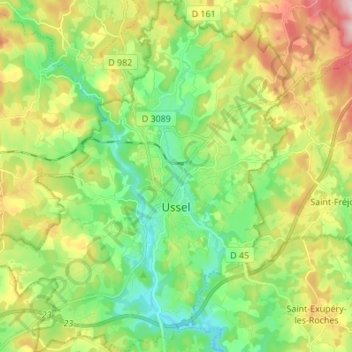
Name: Ussel topographic map, elevation, terrain.
Average elevation: 680 m
Minimum elevation: 582 m
Maximum elevation: 845 m