
Thank you for supporting this site ❤️
Make a donation
Make a donation
Ribérac topographic map
Click on the map to display elevation.
Thank you for supporting this site ❤️
Make a donation
Make a donation
Ribérac
Ribérac is on the left bank of the Dronne. To the north, the soil in the Dronne valley is covered with alluvium, while the heights are made up of Cretaceous limestones. Its minimum altitude, 54 meters, is located in the extreme north-west of the town, where a small arm of the Dronne leaves the town.
Thank you for supporting this site ❤️
Make a donation
Make a donation
About this map
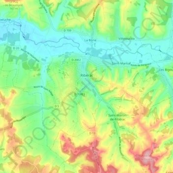
Name: Ribérac topographic map, elevation, terrain.
Average elevation: 107 m
Minimum elevation: 53 m
Maximum elevation: 198 m
Thank you for supporting this site ❤️
Make a donation
Make a donation