
Thank you for supporting this site ❤️
Make a donation
Make a donation
Madathara topographic map
Click on the map to display elevation.
Thank you for supporting this site ❤️
Make a donation
Make a donation
About this map
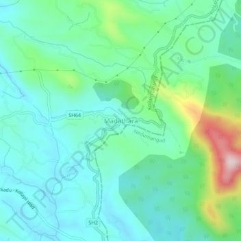
Name: Madathara topographic map, elevation, terrain.
Location: Madathara, Kottarakkara, Kollam District, Kerala, 691541, India (8.79770 76.99328 8.83770 77.03328)
Average elevation: 180 m
Minimum elevation: 92 m
Maximum elevation: 468 m
Thank you for supporting this site ❤️
Make a donation
Make a donation
Other topographic maps
Click on a map to view its topography, its elevation and its terrain.