
Make a donation
Mexico City topographic map
Click on the map to display elevation.
Make a donation
Mexico City
Mexico City (Spanish: Ciudad de México, locally [sjuˈða(ð) ðe ˈmexiko] (listen); abbr.: CDMX; Nahuatl: Āltepētl Mēxihco Nahuatl pronunciation: [ɑːl'tɛpeːt͡ɬ meːʃi'ko]) is the capital and largest city of Mexico, and the most populous city in North America. One of the world's alpha cities, it is located in the Valley of Mexico within the high Mexican central plateau, at an altitude of 2,240 meters (7,350 ft). The city has 16 boroughs or demarcaciones territoriales, which are in turn divided into neighborhoods or colonias.
Make a donation
About this map
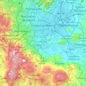
Name: Mexico City topographic map, elevation, terrain.
Location: Mexico City, Mexico (19.04872 -99.36492 19.59276 -98.94030)
Average elevation: 2,619 m
Minimum elevation: 2,223 m
Maximum elevation: 3,915 m
Make a donation
Other topographic maps
Click on a map to view its topography, its elevation and its terrain.
Toluca
Mexico > State of Mexico > Toluca
Toluca is located at 2600 meters above sea level, being the highest capital city in Mexico and North America, which makes it temperate throughout the year with average temperatures ranging between 6 and 25 degrees Celsius during spring and summer, and from −5 to 20 degrees Celsius in winter. Its climate is…
Average elevation: 2,729 m
San Mateo Coapexco, Villa Guerrero Edo. Mex.
Mexico > State of Mexico > Villa Guerrero > San Mateo Coapexco, Villa Guerrero Edo. Mex.
Average elevation: 2,176 m
Make a donation