
Thank you for supporting this site ❤️
Make a donation
Make a donation
Bouéni topographic map
Click on the map to display elevation.
Thank you for supporting this site ❤️
Make a donation
Make a donation
About this map
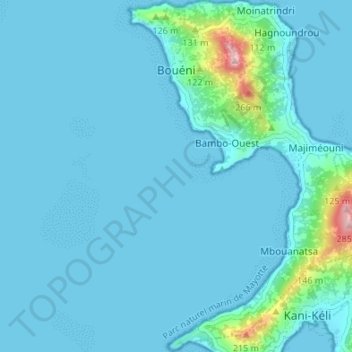
Name: Bouéni topographic map, elevation, terrain.
Location: Bouéni, Mayotte, 97620, France (-12.96333 45.07093 -12.89767 45.12670)
Average elevation: 23 m
Minimum elevation: 0 m
Maximum elevation: 276 m
Thank you for supporting this site ❤️
Make a donation
Make a donation
Other topographic maps
Click on a map to view its topography, its elevation and its terrain.