
Thank you for supporting this site ❤️
Make a donation
Make a donation
Ourthe topographic map
Click on the map to display elevation.
Thank you for supporting this site ❤️
Make a donation
Make a donation
About this map
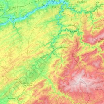
Name: Ourthe topographic map, elevation, terrain.
Location: Ourthe, Marche-en-Famenne, Luxemburg, Wallonië, 4130, België (50.13321 5.37836 50.62309 5.67913)
Average elevation: 293 m
Minimum elevation: 59 m
Maximum elevation: 654 m
Thank you for supporting this site ❤️
Make a donation
Make a donation
Other topographic maps
Click on a map to view its topography, its elevation and its terrain.