Geolocate

Churchover CP topographic map

Click on the map to display elevation.

About this map

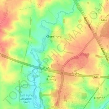
Name: Churchover CP topographic map, elevation, terrain.

Location: Churchover CP, Rugby, Warwickshire, England, United Kingdom (52.39430 -1.26540 52.43602 -1.21296)

Average elevation: 115 m

Minimum elevation: 87 m

Maximum elevation: 140 m

Other topographic maps

Click on a map to view its topography, its elevation and its terrain.

Newton

United Kingdom > England > Warwickshire > Rugby

Average elevation: 114 m

Draycote Water

United Kingdom > England > Warwickshire > Rugby > Draycote

Average elevation: 92 m

Newbold on Avon

United Kingdom > England > Warwickshire > Rugby

Average elevation: 98 m

Bilton

United Kingdom > England > Warwickshire > Rugby

Average elevation: 111 m

Draycote

United Kingdom > England > Warwickshire > Rugby

Average elevation: 94 m

Newton

United Kingdom > England > Warwickshire > Rugby

Average elevation: 114 m

Bramcote

United Kingdom > England > Warwickshire > Rugby

Average elevation: 105 m

Barnacle

United Kingdom > England > Warwickshire > Rugby > Barnacle

Average elevation: 102 m