
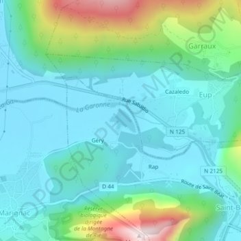
Lac de Géry topographic map
Interactive map
Click on the map to display elevation.
About this map
Name: Lac de Géry topographic map, elevation, terrain.
Average elevation: 618 m
Minimum elevation: 476 m
Maximum elevation: 1,116 m
Other topographic maps
Click on a map to view its topography, its elevation and its terrain.
Bout de la Lande
France > Occitanie > Haute-Garonne > Saint-Béat-Lez
Bout de la Lande, Saint-Béat, Saint-Béat-Lez, Saint-Gaudens, Haute-Garonne, Occitanie, France métropolitaine, 31440, France
Average elevation: 754 m
Ladivert
France > Occitanie > Haute-Garonne > Saint-Béat-Lez
Ladivert, Saint-Béat, Saint-Béat-Lez, Saint-Gaudens, Haute-Garonne, Occitanie, France métropolitaine, 31440, France
Average elevation: 728 m
Saint-Béat
France > Occitanie > Haute-Garonne > Saint-Béat-Lez
Saint-Béat, Saint-Béat-Lez, Saint-Gaudens, Haute-Garonne, Occitanie, France métropolitaine, 31440, France
Average elevation: 872 m
Lez
France > Occitanie > Haute-Garonne > Saint-Béat-Lez
Lez, Saint-Béat-Lez, Saint-Gaudens, Haute-Garonne, Occitanie, France métropolitaine, 31440, France
Average elevation: 720 m