
Thank you for supporting this site ❤️
Make a donation
Make a donation
Gray topographic map
Click on the map to display elevation.
Thank you for supporting this site ❤️
Make a donation
Make a donation
About this map
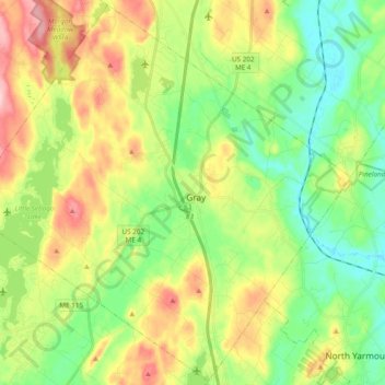
Name: Gray topographic map, elevation, terrain.
Location: Gray, Cumberland County, Maine, 04039, United States (43.81983 -70.44543 43.95524 -70.25317)
Average elevation: 92 m
Minimum elevation: 23 m
Maximum elevation: 204 m
Thank you for supporting this site ❤️
Make a donation
Make a donation
Other topographic maps
Click on a map to view its topography, its elevation and its terrain.
Cliff Island
United States > Maine > Cumberland County > Portland > Cliff Island
Average elevation: 1 m
Thank you for supporting this site ❤️
Make a donation
Make a donation
Thank you for supporting this site ❤️
Make a donation
Make a donation