
Lac Memphrémagog topographic map
Interactive map
Click on the map to display elevation.
About this map
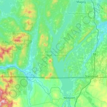
Name: Lac Memphrémagog topographic map, elevation, terrain.
Average elevation: 311 m
Minimum elevation: 151 m
Maximum elevation: 1,153 m
Other topographic maps
Click on a map to view its topography, its elevation and its terrain.
Fitch Bay
Canada > Québec > Memphrémagog > Stanstead (Canton)
Fitch Bay, Stanstead (Canton), Memphrémagog, Estrie, Québec, Canada
Average elevation: 277 m