
Thank you for supporting this site ❤️
Make a donation
Make a donation
Otzenhausen topographic map
Click on the map to display elevation.
Thank you for supporting this site ❤️
Make a donation
Make a donation
About this map
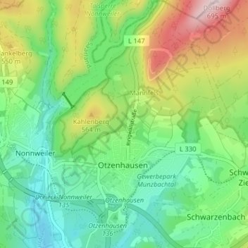
Name: Otzenhausen topographic map, elevation, terrain.
Average elevation: 472 m
Minimum elevation: 360 m
Maximum elevation: 694 m
Thank you for supporting this site ❤️
Make a donation
Make a donation
Other topographic maps
Click on a map to view its topography, its elevation and its terrain.
Schwarzenbach-Ziegelhütte
Deutschland > Saarland > Landkreis St. Wendel > Nonnweiler
Average elevation: 469 m