
Thank you for supporting this site ❤️
Make a donation
Make a donation
Lake Chad topographic map
Click on the map to display elevation.
Thank you for supporting this site ❤️
Make a donation
Make a donation
Lake Chad
Lake Chad has shrunk considerably since the 1960s, when its shoreline had an elevation of about 286 metres (938 ft) above sea level and it had an area of more than 26,000 square kilometres (10,000 sq mi), making its surface the fourth largest in Africa. An increased demand on the lake's water from the local population has likely accelerated its shrinkage over the past 40 years.
Thank you for supporting this site ❤️
Make a donation
Make a donation
About this map
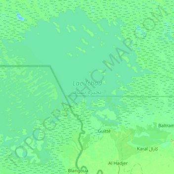
Name: Lake Chad topographic map, elevation, terrain.
Location: Lake Chad, Hadjer-Lamis, Chad (12.78275 14.25009 13.25896 14.77822)
Average elevation: 282 m
Minimum elevation: 274 m
Maximum elevation: 335 m
Thank you for supporting this site ❤️
Make a donation
Make a donation
Other topographic maps
Click on a map to view its topography, its elevation and its terrain.