
Thank you for supporting this site ❤️
Make a donation
Make a donation
Marella topographic map
Click on the map to display elevation.
Thank you for supporting this site ❤️
Make a donation
Make a donation
About this map
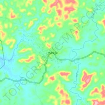
Name: Marella topographic map, elevation, terrain.
Location: Marella, Faranah Region, Guinea (10.13628 -11.45561 10.21628 -11.37561)
Average elevation: 447 m
Minimum elevation: 391 m
Maximum elevation: 590 m
Thank you for supporting this site ❤️
Make a donation
Make a donation
Other topographic maps
Click on a map to view its topography, its elevation and its terrain.