
Thank you for supporting this site ❤️
Make a donation
Make a donation
Ghyaru topographic map
Click on the map to display elevation.
Thank you for supporting this site ❤️
Make a donation
Make a donation
About this map
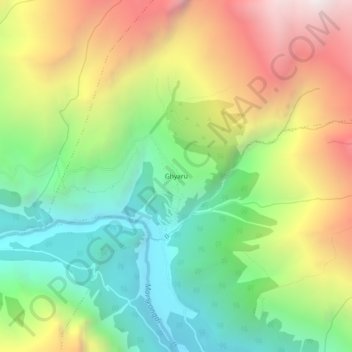
Name: Ghyaru topographic map, elevation, terrain.
Location: Ghyaru, Neshyang-02, Neshyang, Manang, Gandaki Province, Nepal (28.62180 84.11727 28.66180 84.15727)
Average elevation: 3,983 m
Minimum elevation: 3,215 m
Maximum elevation: 5,071 m
Thank you for supporting this site ❤️
Make a donation
Make a donation
Other topographic maps
Click on a map to view its topography, its elevation and its terrain.