
Kings County topographic map
Interactive map
Click on the map to display elevation.
Kings County
Table Mountain is the highest point in Kings County at an elevation of 3,476 feet (1,059 m). It is located in the Diablo Range in southwestern Kings County on the boundary between Kings and Monterey counties.
About this map
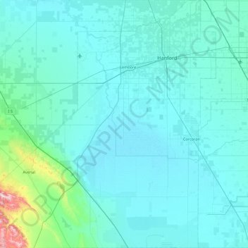
Name: Kings County topographic map, elevation, terrain.
Location: Kings County, California, United States of America (35.78861 -120.31511 36.48883 -119.47438)
Average elevation: 101 m
Minimum elevation: 53 m
Maximum elevation: 828 m
Other topographic maps
Click on a map to view its topography, its elevation and its terrain.
Pasadena
United States of America > California > Pasadena
An obscure portion of the Angeles Crest Highway (SR 2) in the San Gabriel Mountains cuts through Pasadena near the Angeles Crest Ranger Station. This 2-mile (3.2 km) stretch of highway in the Angeles National Forest is north of La Cañada Flintridge and west of Mount Wilson and is approximately 3,000 feet (910…
Average elevation: 549 m
Santa Ana
United States of America > California > Santa Ana
Santa Ana is nested on flat, low-lying plains with little land elevation change. Running through the west end of the city is the mostly channelized Santa Ana River, which is also largely seasonal due to the construction of the Prado Dam and Seven Oaks Dam. The river has caused several severe floods in the 20th…
Average elevation: 30 m