
Make a donation
Tlaxcala topographic map
Click on the map to display elevation.
Make a donation
Tlaxcala
Tlaxcala is a land-locked state situated on the Trans-Mexican Volcanic Belt. The average altitude for the state is 2,230 meters above sea level, making it a bit higher than the Valley of Mexico just to the southwest. The western part of the state lies on the central plateau of Mexico while the east is dominated by the Sierra Madre Oriental, home of the 4,461 meter La Malinche volcano. Most of the state is rugged terrain dominated by ridges and deep valleys, along with protruding igneous rock formations. This ruggedness, along with large-scale weather phenomena such as the Intertropical Convergence Zone, gives the state a complex climate. Overall rain patterns for the state are about 400 mm (16 in) in the summer rainy season and 30 mm (1.2 in) in the winter. Locally, however, this varies dramatically between the drier plateaus and valleys and the wetter mountains. Variations in altitude produce sub-climates between semi-tropical to temperate, with frosts likely in the higher elevations during the winter. Temperate fir (Abies religiosa), juniper (Juniperus deppeana), and pine-oak forests dominate the mountain highlands, while the flatlands, with their drier climate, are characterized by agaves and prickly pear cactus (Opuntia).
Make a donation
About this map
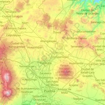
Name: Tlaxcala topographic map, elevation, terrain.
Location: Tlaxcala, Mexico (19.10507 -98.70840 19.72892 -97.62544)
Average elevation: 2,540 m
Minimum elevation: 1,279 m
Maximum elevation: 5,328 m
Make a donation
Other topographic maps
Click on a map to view its topography, its elevation and its terrain.
Toluca
Mexico > State of Mexico > Toluca
Toluca is located at 2600 meters above sea level, being the highest capital city in Mexico and North America, which makes it temperate throughout the year with average temperatures ranging between 6 and 25 degrees Celsius during spring and summer, and from −5 to 20 degrees Celsius in winter. Its climate is…
Average elevation: 2,729 m
San Mateo Coapexco, Villa Guerrero Edo. Mex.
Mexico > State of Mexico > Villa Guerrero > San Mateo Coapexco, Villa Guerrero Edo. Mex.
Average elevation: 2,176 m
Make a donation