
Thank you for supporting this site ❤️
Make a donation
Make a donation
Bourg-Saint-Pierre topographic map
Click on the map to display elevation.
Thank you for supporting this site ❤️
Make a donation
Make a donation
About this map
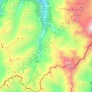
Name: Bourg-Saint-Pierre topographic map, elevation, terrain.
Location: Bourg-Saint-Pierre, Entremont, Wallis, 1946, Switzerland (45.85868 7.13761 45.97421 7.30085)
Average elevation: 2,530 m
Minimum elevation: 1,442 m
Maximum elevation: 4,151 m
Thank you for supporting this site ❤️
Make a donation
Make a donation
Other topographic maps
Click on a map to view its topography, its elevation and its terrain.
Thank you for supporting this site ❤️
Make a donation
Make a donation
Thank you for supporting this site ❤️
Make a donation
Make a donation
Eau-Rouge
Switzerland > Wallis > Entremont > Chamoille (Sembrancher) > Les Champmanins
Average elevation: 1,034 m
Thank you for supporting this site ❤️
Make a donation
Make a donation
Thank you for supporting this site ❤️
Make a donation
Make a donation