
通道县 topographic map
Interactive map
Click on the map to display elevation.
通道县
通道县地处云贵高原东缘向南岭山脉过渡地带,雪峰山西南余脉延伸境内,形成“东、南、西三面高耸,北部隆起,中部凹陷,总体向中、西北倾斜”的地势。 地貌以中山、低山、丘陵为主,其中山地占78%,丘陵占15%。 海拔一般为300-700m。
About this map
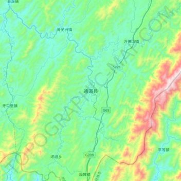
Name: 通道县 topographic map, elevation, terrain.
Location: 通道县, 通道侗族自治县, 怀化市, 湖南省, 中国 (26.00105 109.61985 26.32105 109.93985)
Average elevation: 558 m
Minimum elevation: 284 m
Maximum elevation: 1,537 m