
Thank you for supporting this site ❤️
Make a donation
Make a donation
Farnborough topographic map
Click on the map to display elevation.
Thank you for supporting this site ❤️
Make a donation
Make a donation
Farnborough
Farnborough is located in the northeastern corner of the county of Hampshire, near the border with Surrey. The town occupies a valley setting, with the main urban area situated between the River Blackwater to the east and higher ground to the west. The topography gradually rises from the valley floor, reaching a maximum elevation of around 90 metres (300 feet) above sea level on the fringes of the town.
Thank you for supporting this site ❤️
Make a donation
Make a donation
About this map
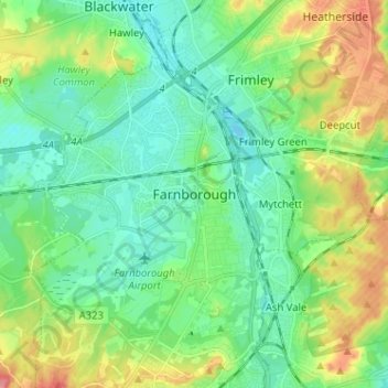
Name: Farnborough topographic map, elevation, terrain.
Average elevation: 82 m
Minimum elevation: 57 m
Maximum elevation: 137 m
Thank you for supporting this site ❤️
Make a donation
Make a donation