
Oban topographic map
Interactive map
Click on the map to display elevation.
About this map
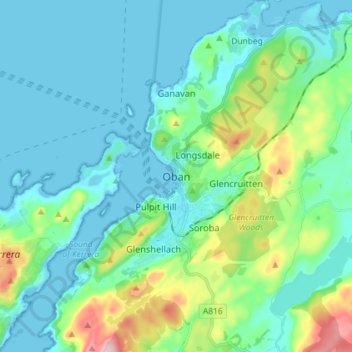
Name: Oban topographic map, elevation, terrain.
Average elevation: 47 m
Minimum elevation: 0 m
Maximum elevation: 237 m
Other topographic maps
Click on a map to view its topography, its elevation and its terrain.
Iona
Verenigd Koninkrijk > Schotland > Argyll and Bute > Baile Mòr
Iona, Baile Mòr, Argyll and Bute, Schotland, Verenigd Koninkrijk
Average elevation: 9 m
North Connel
Verenigd Koninkrijk > Schotland > Argyll and Bute
North Connel, Argyll and Bute, Schotland, PA37 1PL, Verenigd Koninkrijk
Average elevation: 19 m
Argyll and Bute
Verenigd Koninkrijk > Schotland > Argyll and Bute
Argyll and Bute, Schotland, Verenigd Koninkrijk
Average elevation: 84 m