
Cerro Verde topographic map
Interactive map
Click on the map to display elevation.
About this map
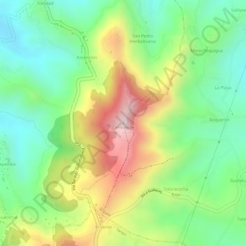
Name: Cerro Verde topographic map, elevation, terrain.
Location: Cerro Verde, El Valle, Cuenca, Azuay, 010211, Ecuador (-2.95483 -79.00108 -2.95473 -79.00098)
Average elevation: 2,804 m
Minimum elevation: 2,634 m
Maximum elevation: 3,043 m
Other topographic maps
Click on a map to view its topography, its elevation and its terrain.
Victoria del Portete
Victoria del Portete, Cuenca, Azuay, Ecuador
Average elevation: 2,933 m
Guagrahuma
Guagrahuma, Sayausí, Cuenca, Azuay, Ecuador
Average elevation: 3,987 m