
Thank you for supporting this site ❤️
Make a donation
Make a donation
Dhankhola topographic map
Click on the map to display elevation.
Thank you for supporting this site ❤️
Make a donation
Make a donation
About this map
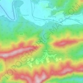
Name: Dhankhola topographic map, elevation, terrain.
Location: Dhankhola, Gadhawa-01, Gadhawa, Dang, Lumbini Province, Nepal (27.76429 82.78248 27.80429 82.82248)
Average elevation: 478 m
Minimum elevation: 307 m
Maximum elevation: 739 m
Thank you for supporting this site ❤️
Make a donation
Make a donation
Other topographic maps
Click on a map to view its topography, its elevation and its terrain.