
Thank you for supporting this site ❤️
Make a donation
Make a donation
West Fork topographic map
Click on the map to display elevation.
Thank you for supporting this site ❤️
Make a donation
Make a donation
West Fork
West Fork is located at 35°56′08″N 94°10′48″W / 35.93556°N 94.18000°W / 35.93556; -94.18000 (35.9356771, -94.1801038) at an elevation of 1,358 feet (414 m). According to the United States Census Bureau, the city has a total area of 3.3 square miles (8.5 km2), all land.
Thank you for supporting this site ❤️
Make a donation
Make a donation
About this map
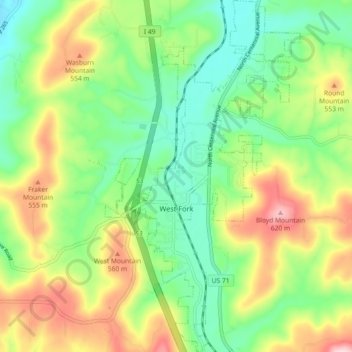
Name: West Fork topographic map, elevation, terrain.
Location: West Fork, Washington County, Arkansas, United States (35.89426 -94.20704 35.96796 -94.15650)
Average elevation: 468 m
Minimum elevation: 367 m
Maximum elevation: 631 m
Thank you for supporting this site ❤️
Make a donation
Make a donation
Other topographic maps
Click on a map to view its topography, its elevation and its terrain.
Thank you for supporting this site ❤️
Make a donation
Make a donation
Thank you for supporting this site ❤️
Make a donation
Make a donation