
Thank you for supporting this site ❤️
Make a donation
Make a donation
Niederzwehren topographic map
Click on the map to display elevation.
Thank you for supporting this site ❤️
Make a donation
Make a donation
Niederzwehren
Nach Norden hin wird Niederzwehren in Richtung Park Schönfeld und Wehlheiden durch die nach Wilhelmshöhe abzweigende Verbindung der Waldkappeler Bahn begrenzt.
Thank you for supporting this site ❤️
Make a donation
Make a donation
About this map
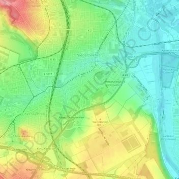
Name: Niederzwehren topographic map, elevation, terrain.
Location: Niederzwehren, Kassel, Hessen, 34134, Deutschland (51.26038 9.44844 51.29999 9.49103)
Average elevation: 173 m
Minimum elevation: 131 m
Maximum elevation: 242 m
Thank you for supporting this site ❤️
Make a donation
Make a donation
Other topographic maps
Click on a map to view its topography, its elevation and its terrain.
Karlsaue
Deutschland > Hessen > Kassel
In der Nähe des Sees steht eine Stieleiche mit einem Brusthöhenumfang von 7,95 m (2015).
Average elevation: 152 m
Thank you for supporting this site ❤️
Make a donation
Make a donation