
Houston topographic map
Click on the map to display elevation.
Houston
Much of the city was built on forested land, marshes, or swamps, and all are still visible in surrounding areas. Flat terrain and extensive greenfield development have combined to worsen flooding. Downtown stands about 50 feet (15 m) above sea level, and the highest point in far northwest Houston is about 150 feet (46 m) in elevation. The city once relied on groundwater for its needs, but land subsidence forced the city to turn to ground-level water sources such as Lake Houston, Lake Conroe, and Lake Livingston. The city owns surface water rights for 1.20 billion U.S. gallons (4.5 Gl) of water a day in addition to 150 million U.S. gallons (570 Ml) a day of groundwater.
About this map
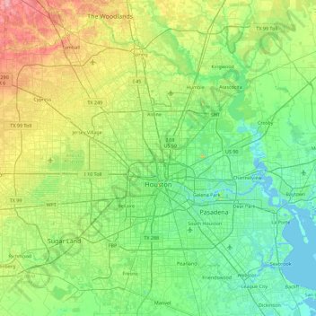
Name: Houston topographic map, elevation, terrain.
Location: Houston, Harris County, Texas, United States (29.53707 -95.90974 30.11035 -95.01205)
Average elevation: 25 m
Minimum elevation: -3 m
Maximum elevation: 98 m
Other topographic maps
Click on a map to view its topography, its elevation and its terrain.
Highlands
United States > Texas > Harris County
The community was named Highlands because the east bank of the San Jacinto River, where Highlands is located, has a higher elevation than the west bank of the river. By 1908, Highlands became a station on the Beaumont, Sour Lake and Western Railway. A post office opened in 1929. Highlands incorporated in 1930,…
Average elevation: 8 m