
Thank you for supporting this site ❤️
Make a donation
Make a donation
Sommet du Laquina topographic map
Click on the map to display elevation.
Thank you for supporting this site ❤️
Make a donation
Make a donation
About this map
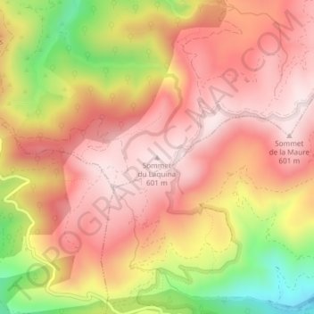
Name: Sommet du Laquina topographic map, elevation, terrain.
Average elevation: 442 m
Minimum elevation: 149 m
Maximum elevation: 605 m
Thank you for supporting this site ❤️
Make a donation
Make a donation
Other topographic maps
Click on a map to view its topography, its elevation and its terrain.
Ruisseau de la Sauvette
France > Provence-Alpes-Côte d'Azur > Var > Collobrières
Average elevation: 324 m