
Thank you for supporting this site ❤️
Make a donation
Make a donation
Greeter Falls topographic map
Click on the map to display elevation.
Thank you for supporting this site ❤️
Make a donation
Make a donation
About this map
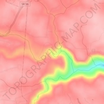
Name: Greeter Falls topographic map, elevation, terrain.
Average elevation: 550 m
Minimum elevation: 430 m
Maximum elevation: 575 m
Thank you for supporting this site ❤️
Make a donation
Make a donation
Other topographic maps
Click on a map to view its topography, its elevation and its terrain.
South Cumberland Recreation Area
United States > Tennessee > Grundy County > Beersheba Springs
Average elevation: 533 m