
Thank you for supporting this site ❤️
Make a donation
Make a donation
Monumento Natural das Portas de Ródão topographic map
Click on the map to display elevation.
Thank you for supporting this site ❤️
Make a donation
Make a donation
About this map
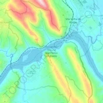
Name: Monumento Natural das Portas de Ródão topographic map, elevation, terrain.
Average elevation: 167 m
Minimum elevation: 69 m
Maximum elevation: 406 m
Thank you for supporting this site ❤️
Make a donation
Make a donation
Other topographic maps
Click on a map to view its topography, its elevation and its terrain.
Thank you for supporting this site ❤️
Make a donation
Make a donation
Barragem Romana da Lameira
Portugal > Castelo Branco > Vila Velha de Ródão > Perais
Average elevation: 191 m
Thank you for supporting this site ❤️
Make a donation
Make a donation
Gavião do Ródão
Portugal > Castelo Branco > Vila Velha de Ródão > Gavião do Ródão
Average elevation: 261 m
Thank you for supporting this site ❤️
Make a donation
Make a donation