
Thank you for supporting this site ❤️
Make a donation
Make a donation
Prießnitz topographic map
Click on the map to display elevation.
Thank you for supporting this site ❤️
Make a donation
Make a donation
Prießnitz
Prießnitz liegt zwischen Jena und Naumburg (Saale) auf einem erhöhten überlössten Ackerbaustandort südlich der Saaleanhöhen bei Naumburg.
Thank you for supporting this site ❤️
Make a donation
Make a donation
About this map
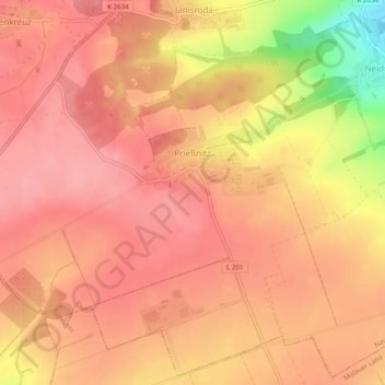
Name: Prießnitz topographic map, elevation, terrain.
Average elevation: 251 m
Minimum elevation: 178 m
Maximum elevation: 275 m
Thank you for supporting this site ❤️
Make a donation
Make a donation
Other topographic maps
Click on a map to view its topography, its elevation and its terrain.
Thank you for supporting this site ❤️
Make a donation
Make a donation
Hassenhausen
Deutschland > Sachsen-Anhalt > Burgenlandkreis > Naumburg (Saale)
Average elevation: 225 m
Kreipitzsch
Deutschland > Sachsen-Anhalt > Burgenlandkreis > Naumburg (Saale)
Average elevation: 206 m
Thank you for supporting this site ❤️
Make a donation
Make a donation