
Thank you for supporting this site ❤️
Make a donation
Make a donation
Losheimergraben topographic map
Click on the map to display elevation.
Thank you for supporting this site ❤️
Make a donation
Make a donation
Losheimergraben
Losheimergraben ligt op ongeveer 670 meter hoogte boven de zeespiegel. In de nabijheid van het gehucht ontspringen de rivieren de Kyll, de Warche en de Our. Losheimergraben ligt op de waterscheiding tussen de stroomgebieden van de Maas (vanaf de Warche) en de Rijn (vanaf Kyll en Our).
Thank you for supporting this site ❤️
Make a donation
Make a donation
About this map
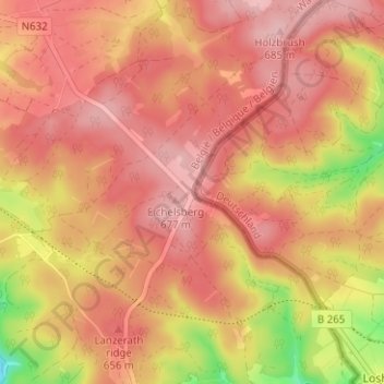
Name: Losheimergraben topographic map, elevation, terrain.
Average elevation: 634 m
Minimum elevation: 529 m
Maximum elevation: 682 m
Thank you for supporting this site ❤️
Make a donation
Make a donation
Other topographic maps
Click on a map to view its topography, its elevation and its terrain.