
Make a donation
Tirana topographic map
Click on the map to display elevation.
Make a donation
Tirana
Tirana extends at the Plain of Tirana in the centre of Albania between the mount of Dajti in the east, the hills of Kërrabe, Sauk and Vaqarr in the south, and a valley to the north overlooking the Adriatic Sea. The average altitude is about 110 meters (360 ft) above sea level, with a maximum of 1,828 metres (5,997 feet) at Maja Mincekut of Mali me Gropa in Shenmeri.
Make a donation
About this map
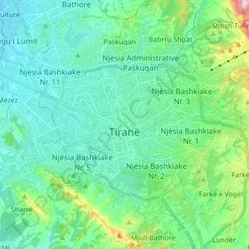
Name: Tirana topographic map, elevation, terrain.
Average elevation: 146 m
Minimum elevation: 53 m
Maximum elevation: 541 m
Make a donation
Other topographic maps
Click on a map to view its topography, its elevation and its terrain.
Make a donation
Lagjja e Re (Pezë-Helmësi)
Albania > Central Albania > Tirana County > Pezë > Pezë-Helmës
Average elevation: 130 m
Mullet
Albania > Central Albania > Tirana County
Mullet (Albanian definite form: Mulleti) is a village in Tirana County, Albania. At the 2015 local government reform it became part of the municipality Tirana. It lies at an elevation of 551 feet (167 m).
Average elevation: 208 m
Make a donation
Prengaj (Babrruja)
Albania > Central Albania > Tirana County > Kamëz Municipality > Babrru Shpat
Average elevation: 152 m
Liqeni i Farkës
Albania > Central Albania > Tirana County > Farkë > Farkë e Vogël > Mollasej (Farka e Vogël)
Average elevation: 194 m
Make a donation
Shporesh (Priskë e Madhe)
Albania > Central Albania > Tirana County > Dajt > Priskë e Madhe
Average elevation: 571 m
Make a donation
Mollasej (Farka e Vogël)
Albania > Central Albania > Tirana County > Farkë > Farkë e Vogël
Average elevation: 200 m
Make a donation
Make a donation
Make a donation
Bathore (Kamëz)
Albania > Central Albania > Tirana County > Kamëz Municipality
Average elevation: 69 m
Make a donation
Shëngjin i Madh
Albania > Central Albania > Tirana County > Tirana Municipality > Shëngjin i Madh
Average elevation: 848 m