Mason topographic map
Interactive map
Click on the map to display elevation.
About this map
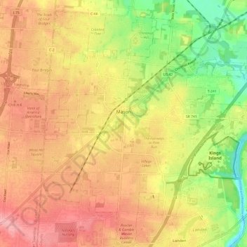
Name: Mason topographic map, elevation, terrain.
Location: Mason, Warren County, Ohio, 45040, United States (39.30954 -84.34936 39.40161 -84.25276)
Average elevation: 248 m
Minimum elevation: 178 m
Maximum elevation: 301 m
Other topographic maps
Click on a map to view its topography, its elevation and its terrain.
Harlan Township
United States > Ohio > Warren County
Harlan Township, Warren County, Ohio, United States
Average elevation: 268 m
Middleboro
United States > Ohio > Warren County
Middleboro, Harlan Township, Warren County, Ohio, United States
Average elevation: 268 m
Springboro
United States > Ohio > Warren County
Springboro, Warren County, Ohio, 45066, United States
Average elevation: 263 m
Mary Ellen
United States > Ohio > Warren County > South Lebanon
Mary Ellen, South Lebanon, Hamilton Township, Warren County, Ohio, 45065, United States
Average elevation: 220 m
Clearcreek Township
United States > Ohio > Warren County
Clearcreek Township, Warren County, Ohio, 45066, United States
Average elevation: 282 m
Kings Mills
United States > Ohio > Warren County
Kings Mills, Deerfield Township, Warren County, Ohio, 45034, United States
Average elevation: 221 m
Lebanon
United States > Ohio > Warren County
Lebanon, Warren County, Ohio, 45036, United States
Average elevation: 246 m
Red Lion
United States > Ohio > Warren County
Red Lion, Clearcreek Township, Warren County, Ohio, United States
Average elevation: 279 m
Loveland Park
United States > Ohio > Warren County > Loveland Park
Loveland Park, Deerfield Township, Warren County, Ohio, United States
Average elevation: 229 m
Maineville
United States > Ohio > Warren County
Maineville, Hamilton Township, Warren County, Ohio, United States
Average elevation: 241 m
South Lebanon
United States > Ohio > Warren County
South Lebanon, Warren County, Ohio, 45065, United States
Average elevation: 219 m
Middletown Junction
United States > Ohio > Warren County
Middletown Junction, Hamilton Township, Warren County, Ohio, 45034, United States
Average elevation: 217 m
Landen
United States > Ohio > Warren County > Landen
Landen, South Cove, Landen, Deerfield Township, Warren County, Ohio, United States
Average elevation: 242 m
Oregonia
United States > Ohio > Warren County
Oregonia, Warren County, Ohio, 45054, United States
Average elevation: 271 m
Fort Ancient State Memorial
United States > Ohio > Warren County > Senior
Fort Ancient State Memorial, Senior, Warren County, Ohio, United States
Average elevation: 261 m
Waynesville
United States > Ohio > Warren County
Waynesville, Warren County, Ohio, 45068, United States
Average elevation: 254 m
Hamilton Township
United States > Ohio > Warren County
Hamilton Township, Warren County, Ohio, 45039, United States
Average elevation: 238 m
Union Run
United States > Ohio > Warren County > Mason
Union Run, Mason, Deerfield Township, Warren County, Ohio, 45039-8700, United States
Average elevation: 240 m
Deerfield Township
United States > Ohio > Warren County
Deerfield Township, Warren County, Ohio, 45034, United States
Average elevation: 240 m
Polk Run
United States > Ohio > Warren County > Montgomery
Polk Run, Montgomery, Deerfield Township, Warren County, Ohio, 45249-1736, United States
Average elevation: 246 m
Morrow
United States > Ohio > Warren County
Morrow, Warren County, Ohio, United States
Average elevation: 226 m
Franklin
United States > Ohio > Warren County
Franklin, Franklin Township, Warren County, Ohio, 45005, United States
Average elevation: 232 m