
Thank you for supporting this site ❤️
Make a donation
Make a donation
Lamar topographic map
Click on the map to display elevation.
Thank you for supporting this site ❤️
Make a donation
Make a donation
About this map
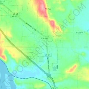
Name: Lamar topographic map, elevation, terrain.
Location: Lamar, Johnson County, Arkansas, United States (35.40499 -93.43400 35.46764 -93.37423)
Average elevation: 139 m
Minimum elevation: 104 m
Maximum elevation: 226 m
Thank you for supporting this site ❤️
Make a donation
Make a donation
Other topographic maps
Click on a map to view its topography, its elevation and its terrain.
Thank you for supporting this site ❤️
Make a donation
Make a donation
Thank you for supporting this site ❤️
Make a donation
Make a donation