
Make a donation
Gornera topographic map
Click on the map to display elevation.
Make a donation
About this map
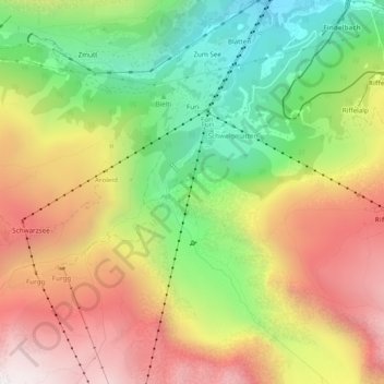
Name: Gornera topographic map, elevation, terrain.
Location: Gornera, Zermatt, Visp, Wallis, 3920, Switzerland (45.97788 7.72683 46.01117 7.74740)
Average elevation: 2,226 m
Minimum elevation: 1,642 m
Maximum elevation: 2,843 m
Make a donation
Other topographic maps
Click on a map to view its topography, its elevation and its terrain.
Furi
Switzerland > Wallis > Visp > Zermatt
Furi is an alpine hamlet in the Pennine Alps, located three kilometers south of Zermatt, Switzerland at an altitude of 1,687m. It is located on a relatively flat area of land between the Gornera and Zmuttbach rivers.
Average elevation: 2,206 m
Monte Rosa
Switzerland > Wallis > Visp > Zermatt
The peak is distinguished by the name Dufourspitze (in German, lit. Dufour Peak; French: Pointe Dufour, Italian: Punta Dufour). This replaced the former name Höchste Spitze (English: Highest Peak) that was indicated on the Swiss maps before the Federal Council, on January 28, 1863, decided to rename the…
Average elevation: 4,033 m
Make a donation
Monte Rosa
Switzerland > Wallis > Visp > Zermatt
The peak is distinguished by the name Dufourspitze (in German, lit. Dufour Peak; French: Pointe Dufour, Italian: Punta Dufour). This replaced the former name Höchste Spitze (English: Highest Peak) that was indicated on the Swiss maps before the Federal Council, on January 28, 1863, decided to rename the…
Average elevation: 4,033 m