
Thank you for supporting this site ❤️
Make a donation
Make a donation
Rocky Point topographic map
Click on the map to display elevation.
Thank you for supporting this site ❤️
Make a donation
Make a donation
About this map
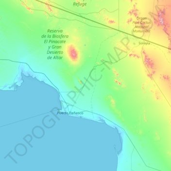
Name: Rocky Point topographic map, elevation, terrain.
Location: Rocky Point, Sonora, Mexico (30.94482 -114.00599 32.11518 -112.43766)
Average elevation: 171 m
Minimum elevation: -2 m
Maximum elevation: 1,411 m
Thank you for supporting this site ❤️
Make a donation
Make a donation
Other topographic maps
Click on a map to view its topography, its elevation and its terrain.
Rocky Point
Mexico > Sonora > Rocky Point
The city of Puerto Peñasco (Rocky Point) is found in the northwest of the Mexican state of Sonora, a state that is located directly to the south of the U.S. state of Arizona. It is located on the eastern coast of the Gulf of California approximately 60 miles south of the Arizonan border, only about a…
Average elevation: 9 m